Encyclopedia Dubuque
"Encyclopedia Dubuque is the online authority for all things Dubuque, written by the people who know the city best.”
Marshall Cohen—researcher and producer, CNN
Affiliated with the Local History Network of the State Historical Society of Iowa, and the Iowa Museum Association.
MISSISSIPPI RIVER
MISSISSIPPI RIVER. Approximately 500,000,000 years ago LIMESTONE formed in a shallow Ordovician seabed. Unlike in other areas which underwent geologic stress causing the layers of sedimentary rock to be buckled by continental plates, the stone around Dubuque remained in layers. Gradually Midwestern limestone was slowly lifted about 600 feet above sea level and 1,000 miles from the sea. Here in the Driftless Plain, the rock was not carved or buried by any but the oldest glaciers. (1)
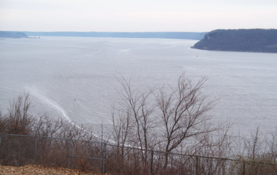
At EAGLE POINT, tourists are looking at half a million years of history. The valley was formed by meltwater from northern glaciers only 15,000 years ago. Summer melt and ice dam breaks caused water rushing along deepening the CHANNEL through the limestone bluffs. During the Ice Age, the river ran faster. Sea level was 500 feet lower than in modern times causing the water to rush more quickly along the slope to the Gulf of Mexico. When glaciers finished melting and sea level reached its present level, the pace of the river slowed. Materials carried by the water were dropped and the river began its meander through its flood plain. (2)
The Mississippi River, one of the world’s major river systems in size, habitat diversity and biological productivity, is the second longest river in the United States. (3) It flows approximately 2,350 miles from its source at Lake Itasca through the center of the continental United States to the Gulf of Mexico. There are competing claims as to the Mississippi's length. The staff of Itasca State Park at the Mississippi's headwaters say the river is 2,552 miles long. The US Geologic Survey has published a number of 2,300 miles, the Environmental Protection Association says it is 2,320 miles long, and the Mississippi National River and Recreation Area suggests the river's length is 2,350 miles. The reported length of a river may increase or decrease as deposition or erosion occurs at its delta, or as meanders are created or cutoff. (4)
At Lake Itasca, the river is between 20 and 30 feet wide, the narrowest stretch for its entire length. The widest part of the Mississippi can be found at Lake Winnibigoshish near Bena, Minnesota where it is wider than 11 miles. The widest navigable part of the Mississippi is Lake Pepin, where it is approximately 2 miles wide. (5)
At the headwaters of the Mississippi, the average surface speed of the water is near 1.2 miles per hour - approximately one-third a person's walking speed. At New Orleans the river flows 3 miles per hour on average. (6)
The Mississippi River watershed is the fourth largest in the world. It extends from the Allegheny Mountains in the east to the Rocky Mountains in the west. The watershed includes all or parts of 31 states and 2 Canadian Provinces and measures approximately 1.2 million square miles, covering about 40% of the lower 48 states. (7)
The upper Mississippi extends from St. Paul to the mouth of the Missouri River near St. Louis, Missouri. The river in this area led Algonquian-speaking Indians to name it the “Father of Waters” (literally misi, “big”; sipi, “water”). Below the Missouri River junction, the middle Mississippi follows a 200-mile (320-km) course to the mouth of the Ohio River. The turbulent and cloudy-to-muddy, Missouri, especially when in flood, adds enormous quantities of silt to the clearer Mississippi. Beyond the confluence with the Ohio at Cairo, Illinois, the lower Mississippi swells to more than twice the size it is above. Often 1.5 miles (2.4 km) from bank to bank, the lower Mississippi becomes a brown, lazy river, descending toward the Gulf of Mexico. (8)
The river was discovered by Hernando DeSoto in 1541. The history of white inhabitants along the Mississippi begins with the voyage of Louis JOLLIET and Father Jacques MARQUETTE and their entry into the river on June 17, 1673. (9) Louis Hennepin, a Franciscan friar, later managed a phonetic spelling of "Meschasipi" on his maps. (10) In 1703 William Delisle, a French cartographer, changed the spelling to the word recognized today. (11) The source of the mighty waterway was not known until Henry Rowe SCHOOLCRAFT discovered it flowing from Lake Itasca in 1832. (12)
These voyagers were warned by the Indians before going onto the river that it was inhabited by demons and giant fish that would most certainly destroy them. Mark Twain believed Indian traditions were based on the presence of giant sturgeon, paddlefish and catfish. In "Life on the Mississippi," he wrote of having seen monstrous-sized catfish "six feet long, weighing 250 pounds." (13)
When white men first visited Iowa, the Mississippi was a major source of food for the native Indians. The great burial mounds along the Mississippi River contain evidence that prehistoric tribes depended greatly on this "Father of Waters" for stable food supplies of both freshwater mussels and fishes. Geologists believe the Mississippi has existed for two hundred million years. (14)
The Mississippi created a barrier to expansion westward in the early years of American colonization. Development of the Mississippi River Valley was also halted by battles between England and France for control of the area. In 1798 the Mississippi Territory was created by Congress.
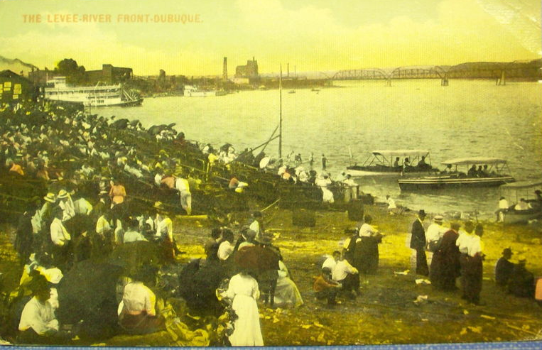
The economic value of the Mississippi River was recognized by the early French trappers who carried their loads of furs along its currents. American farmers' concerns about French control of the river and the right of deposit in New Orleans led to the purchase of the Louisiana Territory from France in 1803. STEAMBOATING opened the river commerce to high class travel through the middle of the 19th century. Today COMMERCIAL FISHING and CLAM HUNTING remain valuable industries.
Control of the Mississippi was a vital concern to both the North and South during the CIVIL WAR. Disruption of river commerce out of Dubuque ended with the fall of Vicksburg on July 4, 1863. This decisive battle led to Union control of the Mississippi and isolation for the forces of the Confederacy west of the river.
Growth of RAILROADS led to a decline in the use of the Mississippi for the LUMBER INDUSTRY. In November 1896 the Dubuque Daily Herald reported that the DIAMOND JO LINE would have a good-sized fleet of vessels in the Upper Mississippi during 1897 but there would be "no effort to outdo, or even equal the old time service." (15) Raftboats became more scarce as the sawmill business decreased. Gradually great fleets of barges revitalized river commerce. By the start of the 21st century, most of the bulk cargo of the Midwest is now carried on the river.
Navigation on the Mississippi is possible from the Falls of St. Anthony in Minnesota to the mouth of the Mississippi in the Gulf of Mexico. Never easily navigable, the river frequently changed course. Droughts left the water level too low for such businesses as lumber milling which, in its early years, floated logs to mills. (16) Navigation of the river was also impacted by rapids.
It was George Wallace JONES who first raised the issue in Congress as a delegate in Congress from the Territory of Michigan. (17) In 1834 he introduced an appropriations bill for $75,000 for the "improvement of the rapids on the Mississippi River." President Jackson was convinced by Jones not to veto the bill which led to the first survey of the rapids. (18) The first navigation project on the Upper Mississippi, however, was the improvement of the Dubuque ICE HARBOR by the U.S. Corps of Engineers in 1844 with a cost of $7,500.
A convention of nine states attended a convention in Burlington, Iowa on October 24, 1851. Representatives of the states of Iowa, Illinois, Wisconsin, Missouri, and the Territory of Minnesota affirmed the value of the Mississippi as a "great national highway" and that it was up to the "National Legislature" to make such improvements to it that midwestern states could compete for commerce with those states in the east. It was resolved that Congress should make appropriations for the removal of obstructions in the river. Those in attendance planned to meet again the next year. (19)
The federal government, founding the Mississippi River Commission in 1879, created a seven-member group of engineers interested in navigational improvement and flood control. A four-and-one-half-foot channel project was begun in 1878. The depth of the channel was to be maintained by clearing the channel and constructing WING DAMS. Finding the depth of the channel insufficient, a second project was initiated in 1907 that called for a six-foot channel maintained by the construction of additional wing dams. (20) This project was of special interest to the UPPER MISSISSIPPI RIVER IMPROVEMENT ASSOCIATION.
As early as 1908 James J. Hill, railroad developer, predicted that Northwest and Midwest businessmen would need to rely on towboats and barges to move their commerce due to congested railways and high charges. He found that the average railway freight charge was 7.5 mills per ton while on the Great Lakes it was 1 mill and on the Ohio River 1/3 of a mill.
The Transportation Act of 1920 passed by Congress established the Inland Waterways Corporation in 1924. Government-owned, the corporation operated on the main channel of the Mississippi with the bulk of the business being between St. Louis, Missouri and New Orleans where channel depth permitted large, heavily-loaded barges. North of St. Louis, the river was being improved for a six-foot channel which was not available at all times. Barges loaded for the nine-foot channels on the Ohio and lower Mississippi could not navigate the upper river. Barges either had to be loaded light at all ties, or unloaded at St. Louis into smaller barges. (21)
In 1925 R. P. Warner, vice-president of the Mississippi Valley Association, noted that manufacturers and distributors in the Midwest were at a tremendous disadvantage. Their competition along the coasts could send send their products more cheaply through the Panama Canal. (22)
Continuing interest in developing a sustainable river commerce led in 1925 to City Manager C. E. Douglas mailing letters an estimated sixty letters to the mayors of cities along the Mississippi in Iowa, Wisconsin and Illinois. In these letters he asked the city councils in these cities to endorse a development proposal similar to the one adopted in Dubuque. He also enlisted Davenport radio station WOC in providing ten minutes for a broadcast advocating a waterway development program. (23) Commerce along the river was dramatically increased with the development of the FEDERAL BARGE LINE of which the UPPER MISSISSIPPI BARGE LINE COMPANY later became a part.
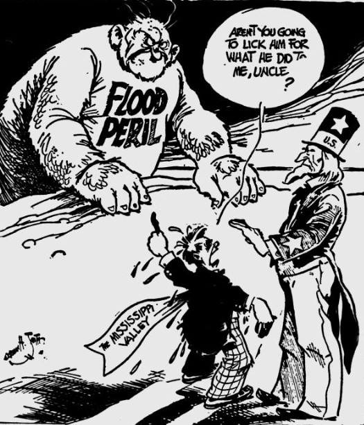
In 1917 the first federal flood control acts were passed. Hundreds of millions of new dollars poured into the system after disastrous flooding in 1927. Dubuque's FLOODWALL cost $10.8 million. Despite preventive measures, unexpected floods continue to be a problem. A severe drought in 1988, a reverse situation, led barges to be stranded with tons of cargo until new channels could be dredged.
On September 8, 1932 an Upper Mississippi Waterway Association was formed to coordinate efforts of all groups in Minnesota, Wisconsin, Illinois and Iowa on behalf of the nine-foot river channel which was considered vital to the northwest. (24)
In 1933 Senator Richard Louis MURPHY expressed belief that an allotment of $22 million of public works funds for work on a nine-foot channel project would succeed. President Franklin D. Roosevelt had taken the question of the nine-foot channel out of Congress and had declared his purpose to complete the project within two and one-half years. (25)
In 2015 there were twenty-seven federal LOCKS between Minneapolis, Minnesota, and the Gulf of Mexico. The creation of the new river system submerged an estimated 125,000 acres of land, converted a free-flowing stream into a series of marshes and standing pools, altered the populations of some types of aquatic life such as clams, and dramatically increased urban growth along the river.
In 1967 the federal government announced that it would no longer lease land along the Mississippi River for residential or cottage sites and that current leases would not be renewed. This affected an 80 mile stretch between Bellevue and Guttenberg that contained 185 leases. (26)
In 2000 the Mississippi was the "highway" for 90 million tons of cargo annually. It was also the home of 115 species of fish and over 300 kinds of birds were found along its shores according to American Rivers, an advocacy group based in Washington, D. C. The upper Mississippi was the home to the largest population of EAGLE (BALD) in the lower 48 states and was the pathway of nearly 40% of migrating birds in the spring and fall. (26)
In 2015 investigation was underway in Dubuque about the possibility of creating HYDROELECTRICITY.
Concern continues about society's impact on the river. In 1980 a report prepared for the UPPER MISSISSIPPI RIVER BASIN COMMISSION concluded that the river system would cease to exist in the next century if current amounts of navigation were continued. Studies indicated that backwaters were filling with silt at a rate of between 1.5 and 2.0 inches annually. The annual commercial harvesting of fish indicated a gradual decline in catches resulting from pollution, silt built-up, and disruptions in fishing caused by pleasure and commercial vessels. Some species of clam are no longer found in sections of the Mississippi below cities guilty of pollution.
Decades of pollution and an emphasis on navigation over nature led the Mississippi in 1994 to be listed as "endangered" by American Rivers, an environmental group. In addition to pollution, the river was endangered by straightening 2,000 miles of its length destroying fish and wildlife habitat and removing wetlands that historically lessened the destruction of floods. (28) By 2017 a number of programs had been started to remedy some of the damage done. Regulations of the Iowa Department of Natural Resources limited the size of walleyes that could be kept by anglers. Strong numbers of yellow perch, northern pike, walleye, sauger, and bass were recorded. Turtle management projects had been conducted by students from the UNIVERSITY OF DUBUQUE for ten years. Fairly consistent numbers of snapping, map, and painted turtles have been seen. Turtles were also caught in humane traps, examined, and marked for tracking. Information was reported to the U. S. Fish and Wildlife Service. Populations of eagles, herons, and egrets were strong. (29)
Threats in 2017 remained with ZEBRA MUSSELS and the addition of the ASIAN CARP into tributaries of the Mississippi. Recently snails from a lake in Wisconsin were thrown into CATFISH CREEK with results yet to be known. Heavy barge traffic posed the threat of spill of toxic materials. The loss of habitat caused by sedimentation in the backwaters could only reasonably be solved by preventing runoff. This could be accomplished by planting more vegetation along shorelines. (30)
In 2017 it was announced that the Mississippi River/Gulf Hypoxia Task Force had not met its goal. The group of twelve states bordering the Mississippi had established a goal in 2002 of reducing the Dead Zone in the Gulf of Mexico to 1,900 square miles. The Dead Zone was not a natural occurrence. It was created by the thousands of pounds of fertilizers and raw sewage carried down the Mississippi and dumped into the gulf annually. In 2015 the zone measured an estimated 5,800 square miles--slightly larger than the state of Connecticut. (31) In 2017 the area lacking all aquatic life had grown to over 6,000 square miles. The Mississippi River Collaborative, a group of thirteen state and national conservation groups, blamed the Environmental Protection Agency and the twelve states for failing to reduce excess nitrogen and phosphorus within the watershed enough. The states' dependence on voluntary action and cleanup programs that did not measure results did not work. The EPA had failed to use its authority to require the states to do better. Each of the twelve states had developed its own nutrient reduction strategy resulting in different results. None of the states had set limits on nitrogen and only Minnesota and Wisconsin had set standards for phosphorus in waterways. (32) Interest in reducing the size of the Dead Zone was also an interest of the Mississippi Rivers and Towns Initiative which in 2017 had a goal of increasing education about the issue of pollution and advocating for farmers to adopt practices that reduced runoff. (33)
While only an estimated 5.9 percent of the water entering the Mississippi-Atchafalaya River Basin, covered all or part of 31 states, comes from Iowa, the state contributed an estimated 29% of the nutrient pollution. This finding came from a study announced in August, 2018 by the University of Iowa. Between 1999 and 2016 the state witnessed a 47% increase in nutrient pollution in the Gulf of Mexico. (34)
In 2019 a record of 86 consecutive days (March 20-June 13) was set when the Mississippi River was above flood stage at the RAILROAD BRIDGE. This surpassed the previous mark of 37 days set in 2001. (35)
In 2022 a report conducted by the U. S. Geological Survey, Department of the Interior, depicted high water and longer-lasting flooding changing the habitat along the Upper Mississippi River. The area impacted marked by wetlands, marshes, and forests reached from Minnesota to Wisconsin and Iowa to Cairo, Illinois. Previous reports were issued in 1998 and 2008, but did not span decades and examine more than 800 miles of river as in the new study.
Among the findings were that more water was running through the river. Climate change causing heavier rainfall, more snow and higher temperatures along with land use practices and constructed restraints such as levees all played a role. In the lower portion of the upper basin--Iowa, Missouri, and Illinois--at least 50% of the river is constrained. The upper Midwest was projected to get wetter in the future with an increase in surfaces that were impervious which forced more water into the Mississippi River and its tributaries. Levees and floodwalls have cut off many wetland areas which would slow runoff. Rapid runoff from land led to more sediment and nutrients from the land running into the rivers. This killed native plants in the river and contributed to the Dead Zone, the low-oxygen region at the mouth of the Mississippi in the Gulf of Mexico. Any rebound in the growth of aquatic plants from the widespread loss in the 1980s would slow down water velocity and help sediment to settle. Flooding over longer periods of time threaten trees which die. When they are dead, invasive species of plants move in including reed canarygrass and Japanese hops. EMERALD ASH BORER threatened green ash trees, one of the more abundant tree species in the floodplains. (36)
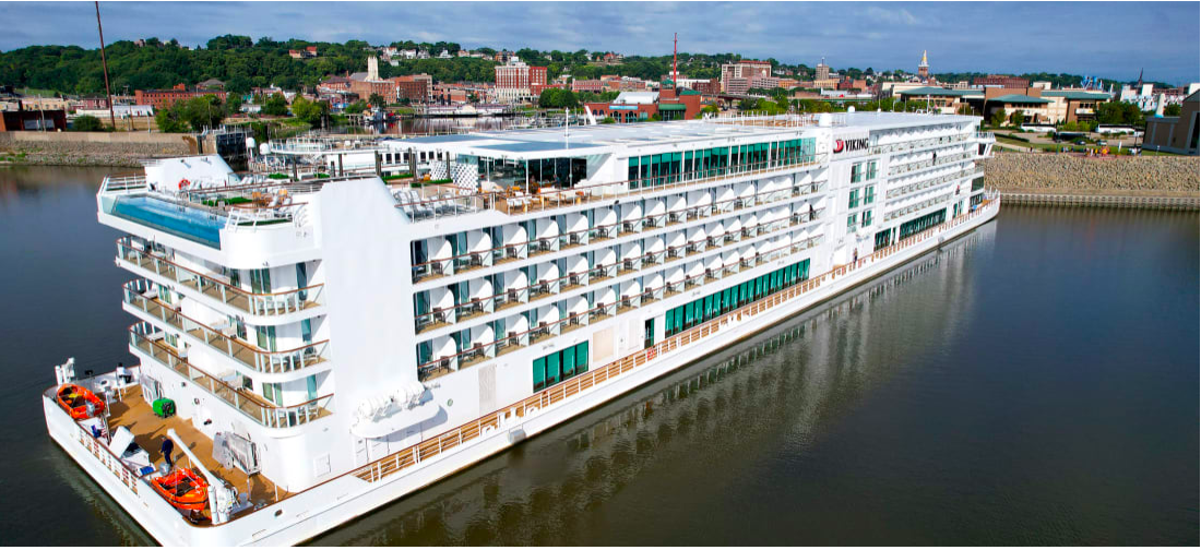
In 2022 the much anticipated appearance along the Upper Mississippi of Viking Cruises ended in early October. A Viking river cruise ship heading north up the Mississippi River could not finish its voyage because of low water levels, according to a statement from the company on October 6th. "Unusually low water levels along the Mississippi River have caused sections of the river to be closed, impacting all northbound and southbound shipping traffic," the statement said. "The closures have caused delays that will prevent the Viking Mississippi from completing the sailing underway and from reaching St. Paul [Minnesota] for her next scheduled departure on October 15." The Viking Mississippi could hold up to 386 guests and was built in 2022, according to the company's website. Viking was advertising a 15-day trip in October from St. Paul to New Orleans starting at $12,999.
The Viking Mississippi was not the only vessel facing problems on the United States' premier river. With drought conditions, low water levels along the Mississippi forced several barges to run aground. The National Oceanic and Atmospheric Administration maintains a drought information website. Its most current report in early October, 2022 said almost 53% of the lower 48 states were in a drought. Drought and abnormal dryness "continue to develop and intensify from the Plains through the Mississippi River Basin, and have now extended further into the Midwest and Southeast. Low water levels are impacting barge traffic on the Mississippi River during the harvest, a crucial time," NOAA's site said. (37)
See: UPPER MISSISSIPPI RIVER NATIONAL WILDLIFE AND FISH REFUGE
---
Source:
1. Koch, Kevin, "A Geological Road Trip," Telegraph Herald, October 13, 2019, p. 5D
2. Ibid.
3. "Major Rivers in USA," Maps of the World, Online: http://www.mapsofworld.com/usa/usa-river-map.html
4. Ibid.
5. "Mississippi," National Park Service, Online: http://www.nps.gov/miss/riverfacts.htm
6. Ibid.
7. Ibid.
8. Ibid.
9. "Mississippi River," Encyclopedia Britannica, Online: http://www.britannica.com/place/Mississippi-River
10. "Mississippi River," Iowa Department of Natural Resources, Online: http://www.iowadnr.gov/Fishing/Where-to-Fish/Mississippi-River
11. "Louis Hennepin," Canadian Museum of History, Online: http://www.historymuseum.ca/virtual-museum-of-new-france/the-explorers/louis-hennepin-1678-1680/
12. "Guillaume Desisle," Wikipedia, Online: https://en.wikipedia.org/wiki/Guillaume_Delisle#/media/File:Iowa_1718.jpg
13. "Henry Rowe Schoolcraft," The State Historical Society of Missouri, Online: http://shs.umsystem.edu/historicmissourians/name/s/schoolcraft/index.html
14. "Mississippi River," Iowa Department of Natural Resources
15. "On the River," Dubuque Daily Herald, November 25, 1896, p. 5
16. "Lumber," Dubuque Herald, May 5, 1877, p. 4
17. "Mississippi River,"
18. "Improvements of the Upper Mississippi," The Republic November 4, 1851, p. 2. Online: http://chroniclingamerica.loc.gov/lccn/sn82014434/1851-11-04/ed-1/seq-2/#date1=1836&index=16&rows=20&words=Dubuque+mineral&searchType=basic&sequence=0&state=&date2=1864&proxtext=mineral+dubuque+&y=13&x=24&dateFilterType=yearRange&page=1 Research: Jeff Gruber
19. "Local History," Dubuque Herald, September 17, 1876, p. 4. Online: https://news.google.com/newspapers?nid=uh8FjILnQOkC&dat=18760917&printsec=frontpage&hl=en
20. "Mississippi River Division-MRC History," U.S. Army Corps of Engineers, Online: http://www.mvd.usace.army.mil/About/MississippiRiverCommission%28MRC%29/History.aspx
21. "Inland Waterway Development Real," Telegraph-Herald and Times-Journal, August 24, 1930, p. 33
22. "WOC to Put Local Officials Address on the Air Soon," Telegraph Herald, December 20, 1925, 19
23. Ibid.
24. "Chronology," Telegraph Herald, December 31, 1967, p. 17
25. "Upper River Boosters Form Organization," Telegraph-Herald and Times-Journal, September 8, 1932, p. 12
26. "Senator Told Not to Worry About Dubuque," Telegraph-Herald and Times-Journal, September 14, 1933, p. 1
27. Pieters, Jeffrey, "River's Economic Role Threatens Its Natural One," Telegraph Herald, October 16, 2000, p. 1
28. "Group Calls Mississippi Endangered," Telegraph Herald, April 20, 1994, p. 1
29. Yager, Alicia. "Protecting a 'Wildlife Paradise' " Our River: Life and Times on the Mississippi, Telegraph Herald, June 15, 2017, p. 38
30. Ibid.
31. Kruse, John. "You Are About to Enter the Dead Zone," Our River: Life and Times on the Mississippi, Telegraph Herald, June 15, 2017, p. 38
32. "Big River News," Big River, January-February 2017, p. 5
33. Kruse
34. Kruse, John, "Report: Iowa Farms Contribute More to Gulf Pollution," Telegraph Herald, August 6, 2018, p. 3A
35. "2019: By the Numbers," Telegraph Herald, December 29, 2019, p. 1A
36. Heim, Madeline, "Report: High Water, Flooding Changing Mississippi," Telegraph Herald, July 2, 2022, p.5A
37. Amanda Watts, Sara Smart, David Williams and Forrest Brown, CNN, "Viking Cruise Ship CAn't Finish Voyage Because Mississippi River is Too Low," CNN Travel, Updated October 7th, 2022, Online: https://www.cnn.com/travel/article/viking-cruise-low-water-mississippi-river/index.html
In this Tuesday, Sept. 6, 2022, photo, the Viking Mississippi cruise ship docks at the Port of Dubuque in Dubuque, Iowa. (Dave Kettering/Telegraph Herald via AP)


