Encyclopedia Dubuque
"Encyclopedia Dubuque is the online authority for all things Dubuque, written by the people who know the city best.”
Marshall Cohen—researcher and producer, CNN
Affiliated with the Local History Network of the State Historical Society of Iowa, and the Iowa Museum Association.
OLD MAIN HISTORIC DISTRICT
OLD MAIN HISTORIC DISTRICT. The Old Main Historic District includes many of Dubuque’s earliest surviving commercial buildings. The district represents the city’s earliest commercial street and the last of what was always the heart of the city’s downtown center. The combination of industrial and jobbing, wholesale firms with retailers reflects the historic mixed land use model in the city. (1)
Individual building histories indicate that nearly all of the buildings pre-date 1884. Storefront ornamentation frequently represents much later construction dates which are more difficult to document. Many buildings had their origins in the substantial post-Civil War rebuilding of the downtown. A number represent the onset of the wholesaling (mid-1850s) and jobbing industry (mid-1870s) in the city during those same years. (2)
The downtown streets are not aligned with compass directions and do not parallel the river. The original downtown was located on the southern edge of a fairly broad raised terrace. Even today, the elevation drops considerably to the south from Second Street, as well as east from Main Street, and Main Street turns to the west below First Street. Much of what is now raised and solid ground to the east and south of lower Main Street, was originally open water or wetlands seasonally. Considerable filling of low areas was carried on throughout the history of the city. (3)
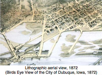
This 1872 city lithograph graphically shows how close the downtown was to the sloughs which separated the city from the MISSISSIPPI RIVER to the east. The area south of Main Street was infilled first by the causeways which connected to the lower wharf, and then by the railroads, which established their stations and yards in this area. The streets within the district, particularly east of Main and south of First, were raised up dramatically to provide additional flood-resistant building sites. (4)
The Dubuque downtown was located along Main between 1st and 3rd streets. By 1853 the center of this district was moving northward, and the first hard surfaced street was on Main between 5th and 6th streets. Beginning in the mid-1850s brick buildings began to replace the original frame store buildings. By 1857 a strong wholesale trade was moving the city’s economy beyond local retail trade and LEAD mine receipts. By 1862 the most valuable portion of Main Street was between 6th and 7th streets where the banks (at 6th) and post office (7th) were located. The south end of Main slipped in economic importance. (5)
By 1872 there was considerable building up of First Street. The east side of Locust Street was filled with largely industrial and warehousing land uses at its southern end. The same was true of Iowa Street. In 1889 little had changed along the lower end of Main Street. The only building up has occurred on the 300s block, along the east side of Main Street. (6)
Dubuque was proud of its downtown, but this pride often seemed beyond boosterism. When Main Street was double tracked for streetcars in mid-October 1884, the Trade Journal observed that “Main Street is "assuming an appearance elegant and metropolitan.” (7)
By 1911 images of the the downtown included the second JULIEN HOTEL, COOPER WAGON WORKS, and the five-story Bell Clothing Factory. (8) Photographs in 1960 show the commercial importance of Main Street, as well as the larger industrial and warehousing plants along Iowa (to the east of Main) and Locust (west of Main). The downtown center, well to the north, presented the tallest buildings. Railroad facilities and track formed the riverfront boundary of the downtown area. (9)
In 1994, the city and the district adopted the Historic Old Main Reinvestment strategy. In 1997 a "place marketing plan," a part of the strategy for the district, was accepted by a DUBUQUE MAIN STREET LTD. committee of property and business owners. The marketing study, costing $30,000 and conducted by Real Estate Planning Group of Chicago and Clarion Associates, was to determine who the area served, the needs of the market and how to achieve them. The first priority was to find other uses for the two adult businesses in the area. The second priority was to focus business planning on Third and Main STREETS, the "gateway" to the entertainment and museum district. Objectives included: (10)
1. promote residential activity in the Old Main area,
2. develop tourism at the ICE HARBOR with museums,
3. develop a theme for the promotion of Old Main,
               4. add details such as a "visible terminus" at the
                  south end of Main Street by flags or street lighting,
               5. develop a business recruitment program targeting
                  start-up businesses by offering an area with low
                  rents and the opportunity to reduce costs by living
                  above the shop,
6. risk mitigation
---
Source:
1. Iowa Site Inventory Form. "Old Main Historic District," Online: http://www.cityofdubuque.org/DocumentCenter/Home/View/2927, p. 27
2. Ibid.
3. Ibid.
4. Ibid. p. 28
5. Ibid., p. 29
6. Ibid., p. 32
7. Ibid.
8. Ibid., p. 35
9. Ibid., p. 36
10. Bergstrom, Kathy. "Report on Old Main Stresses Marketing," Telegraph Herald, February 1, 1997, p. 3A. Online: https://news.google.com/newspapers?nid=aEyKTaVlRPYC&dat=19970201&printsec=frontpage&hl=en


